Description
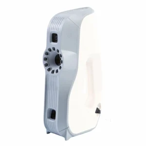
Stonex X120GO Slam 3D Laser Scanner
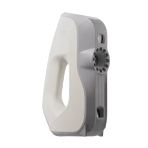
Stonex X120GO Slam 3D Laser Scanner
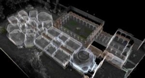
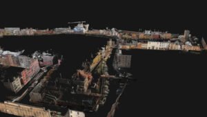
The X120Go is an handheld laser scanner based on the newest STONEX SLAM technology.This powerful scanner allows easy and fast capture of 3D models indoor & outdoor spaces, eliminating the need for complex multi-cloud registrations. Just move around the scene with X120 Go and see the point cloud growing as more data is added in real time.
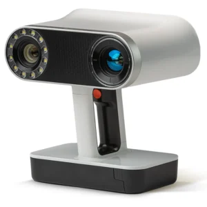
The system has a 360° rotating head, which can generate a 360°x270° point cloud coverage. Combined with the industry-level SLAM algorithm, it can obtain high-precision three-dimensional point cloud data of the surrounding environment without light and GPS. Equipped with three 5MP cameras to generate a 200°FOV horizontal and 100°FOV vertical, capable of synchronously obtaining texture information and producing colour point clouds and partial panoramic images.
You can manage your point clouds in the office with our Cube 3D and Stonex Reconstructor (contact us for pricing) Software or, if you need something different, you can use PointCab (Included in the price). Thanks to the collaboration between Stonex and PointCab, you can process X120GO data with it.
RAPIDITY AND REDUCED WORKLOAD
No more multiple scan station, just move around the scene to collect the entire 3D point cloud, without time-consuming cloud to cloud alignment. Download the full data right after the capture.
FLEXIBILITY
Combine indoor & outdoor data, even in the most demanding environments.
 REAL TIME PREVIEW
 REAL TIME PREVIEW
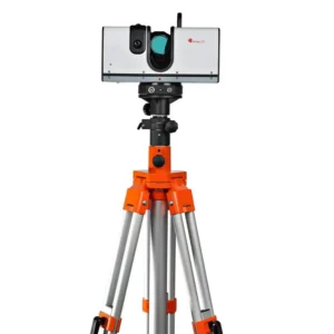
± 5 degrees tilt supplement angle for precise leveling. A 360° one-stop scan requires only 45s.
AUTOMATIC CONTROL POINT MEASUREMENT
When capturing data, X120GO is able to collect reference points too. They can be matched with known control points to georeference the scans.
INTEGRATED CAMERAS
Three integrated 5MP cameras are able to cover the wide field of view of the scanner, obtaining coloured point cloud and panoramic images.
X-WHIZZ MODE
X120GO merges mobile and stationary surveying. To the advantageous SLAM solution that allows you to survey large areas in a very short time, it combines a stationary mode to scan with higher resolution. It is the perfect trade-off for those who need speed and detail in a mobile survey.
SLAM Technology
Simultaneous Localization and Mapping
STONEX SLAM technology delivers more range, more points per second and best in class on board processing algorithms to reach unmatched speed of capture and reliability even in the more demanding environments.
Bundle Software

GOapp
GOapp is dedicate mobile application for X120GO, to manage projects, real time point cloud display, image preview, firmware upgrade and other operations. The APP runs on Android operating system.

GOPost
Windows post processing software which performs optimization processing, colouring of point clouds and creation of panoramic images. You can also import control points into georeference the point cloud.
3D Software
Cube.3d
Cube-3d is a photogrammetric software for mapping and aerial image processsing, dedicate to land surveying specialist. It will transform image data into highly accurate digital maps and 3D models with extremely precision. It import Cube-a surveys and is fully compatible with registered Stonex scans and with any 3rd party 3D models.
PointCab
Thanks to the collaboration between Stonex and PointCab, you can manage your point clouds with it. PointCab origins is your Swiss army knife when it comes to the evaluation of point cloud data – working with all laser scanners and compatible with all CAD and BIM Systems.