Description
Sale Trimble R780 GNSS Rover System, all ROVER options are installed, BASE option is upgradable.
- Activated bands:
GPS: L1C, L1 C/A, L2E (L2P), L2C, L5 - GLONASS: L1C/A, L1P. L2C/A, L2P, L3
- Galileo: E1, E5A, E5B and E5AltBOC, E62
- BeiDou: B1, B2, B3, B1C, B2A
- QZSS: L1 C/A, L1C, L1S, L2C, L5, LEX/L6
- IRNSS: L5
- SBAS: L1 C/A (EGNOS/MSAS GAGAN/SDCM), L1 C/A
- Firmware version have been officially upgraded to the latest version
- Global model, no any regional restrictions. 336 channels supported
- All ROVER options, BASE option is upgradable.
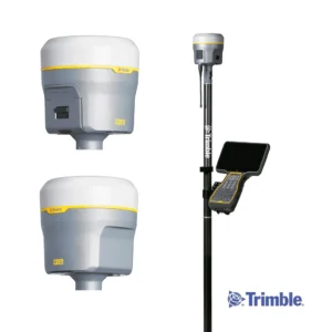
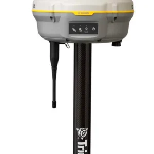
Trimble R780 GNSS systems
The Trimble R780 GNSS receiver allows you to choose your configuration and scale up by adding additional features. With robust GNSS positioning technologies, trust this ultra-durable receiver to boost your productivity and flexibility in any environment. Tougher than Tough Enough. The R780 GNSS Smart Antenna is precise, reliable and versatile. With integrated dual-band radio, the R780 can serve as a GNSS rover system or as a base station. From surveying to machine guidance, the R780 does it all.
Trimble R780 With Tilt Compensation mean that construction surveyors can capture accurate points without leveling the pole to work faster and safer.
Features and Benefits
Rugged, All-In-One Solution
- GNSS receiver, antenna, integrated Wi-Fi, Bluetooth, dual-band radio [450 / 900 MHz] and battery all in one compact and easy-to-use unit
- Eliminate downtime with the most rugged receiver Trimble has ever built – it’s virtually indestructible
- Work more efficiently in the dark or hard to reach locations with a sensor to show verticality on the field controller screen; saving time when you can’t easily see the rod bubble
- Longer battery life keeps you working longer in the field
Tilt Compensation
Using the R780 GNSS Smart Antenna and Trimble Siteworks Positioning Software, capture accurate points while standing, walking or driving the site in a vehicle, while the receiver is not level. From a moving vehicle, capture higher accuracy measurements on steeper slopes and more accurate volume measurements to save time and money on material planning.
- Faster measurements, more efficient stake-outs
- Easy to learn for beginners, saves time for experienced surveyors
- Safely survey hard to reach areas (corners, traffic lanes, utility flowlines)
- No magnetic interference
Flexibility and Performance
- Scalable from entry-level to high precision applications to fit your needs
- Can be easily moved from carrying case to range pole, tripod, t-bar, or vehicle
- Easier and faster to get going and allows for more flexibility of operation techniques
- Integrated dual-band radio to work on any site, switching between 450 and 900 MHz as needed — ideal for mixed fleet operations
- Better performance in challenging GNSS environments (blocked sky, multi-path, or degraded signal) thanks to the dual Trimble Maxwell 7 GNSS ASIC chip and Trimble ProPoint technology
Powered by Trimble Technology
- Trimble ProPoint GNSS technology uses all available signals to provide survey-grade positioning in challenging environments where other GNSS systems fail
- Trimble xFill technology expands site productivity by allowing short excursions into valleys and other locations where GNSS corrections were not previously available
Trimble CenterPoint RTX
- Included for the first 12 months, Trimble CenterPoint RTX is a real-time GNSS corrections service available globally via satellite or the internet. It provides RTK-level accuracy at fast convergence times, without the need for a base station or real-time network. Learn more at rtx.trimble.com
Find out more about Trimble GNSS Correction Services